
How a Brooke County Property Search Proceeds
A search in Brooke County moves in a chain. It runs address to parcel, parcel to owner, owner to deed book/page, and deed to tax and map checks. Addresses are familiar but fragile. An old deed may renumber a street or leave a rural lot unnamed. The parcel number is the sturdier key for the tax roll and the GIS map. Names work too, and one owner can hold several parcels. But a trust, an LLC variant, or a recent sale can hide a match. A sale that has not hit the assessment roll can hide it from a name-only query in the property records.
- Enter the physical address in the Brooke Assessor’s Parcel Address field. If it fails, try a street-name search or omit unit text.
- Open the result and record the account, district/map/parcel, CURRENT OWNER, legal description, and deed book/page.
- Search the County Clerk by the deed reference and party names when the recorded transfer is the question.
- Use MapWV for parcel location, then the Sheriff inquiry for tax year and payment status.
- Ask the custodian about certified copies, older volumes, and any image or building-record access charge.
Brooke Assessor Search Fields by Key
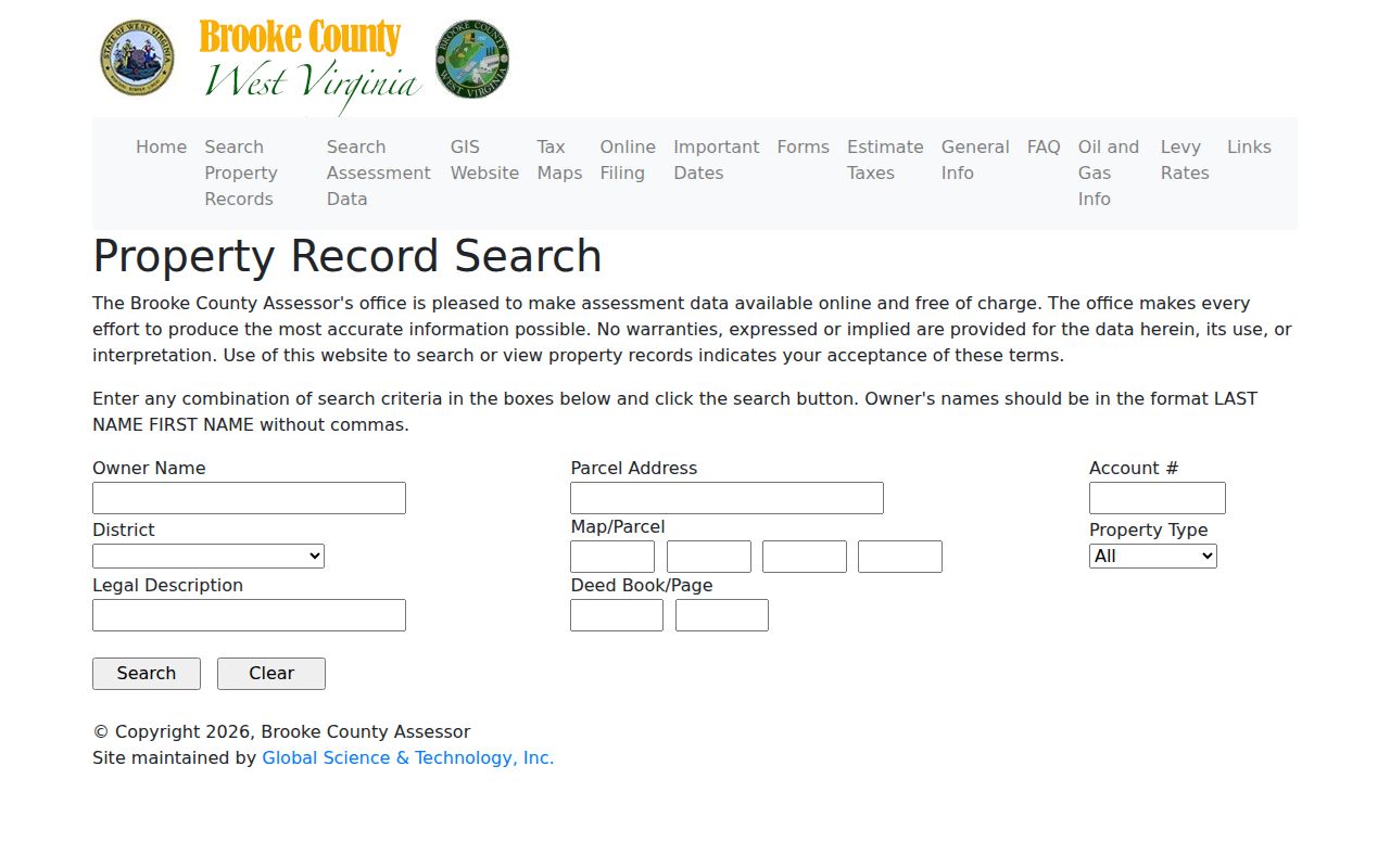
The Brooke Assessor Property Record Search is free. It takes combinations of fields rather than a single required identifier. For Owner Name, type LAST NAME FIRST NAME with no comma. Address queries work from the physical Parcel Address. Weaker queries have alternate routes. These include Account #, District, Map and Parcel boxes, Property Type, Legal Description, and Deed Book/Page.
The county search form appears in the image above. Open the Brooke Assessor search for current field labels and instructions. A hit can show CURRENT OWNER, situs and mailing addresses, and legal description. It can also show sales history, the assessment record, and parcel data. The View Building Record link needs a login. Map card and tax data sit in separate views.
Change one key at a time. That way you know which spelling or parcel piece moved the needle.
| Field | Format | Search use |
|---|---|---|
| Owner Name | Last name, then first name; no comma | Find tax-roll parcels by person or entity |
| Parcel Address | Physical street address | Locate a known site or house |
| Account # / District | County account and district | Refine a bill or assessor result |
| Map/Parcel | Separate text boxes | Use the tax map identifier |
| Legal / Deed Book-Page | Tract words or recorded reference | Find older or renamed locations |
WV Assessment Search Options for Brooke Parcels
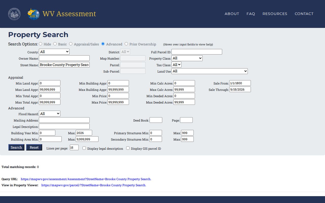
WV Assessment runs a statewide form alongside the Brooke County Assessor's card search. Advanced filters cover county, district, full parcel ID, map number, parcel and subparcel, and owner name. More fields reach street name, property and tax class, land use, deed book and page, legal description, and mailing address. Building year, acreage, and sale-date ranges round out the set. An older parcel reference sometimes refuses to match a street address. These filters give the property search another door.
The image shows the WV Assessment search form. The words "Brooke County Property Search" sit in the street-name field. It returns zero records because the phrase is a demo query, not a real street. Clear that field. Then enter a genuine address or parcel key before reading any result as a Brooke County answer.
Treat the statewide form as a second route. Confirm ownership and deed details with the Brooke Assessor and County Clerk.
What a Brooke County Property Card Reveals
A Brooke assessor card packs several tax and location fields that are easy to mix up. CURRENT OWNER is the name on the tax roll. MAILING ADDRESS tells you where the tax bill goes. STREET ADDRESS marks the parcel's physical spot. The card also lists the legal description, map and parcel numbers, sales history, the assessment record, and a deed book/page for stepping into the County Clerk's deed records.
| Current Owner | Tax-roll name shown on the assessor card |
|---|---|
| Mailing / Street Address | Tax-mail destination versus physical parcel location |
| Map/Parcel | Tax-map components that connect to GIS |
| Assessment Record | Taxable and appraisal information for the roll |
| Legal Description | Lot, tract, subdivision, or survey wording |
| Deed Book/Page | Reference to follow into recorded land records |
The card has limits, though. It does not certify title, list every lien, prove occupancy, or set a legal boundary. Sales History is a clue, not a full chain of conveyance. For a transfer, rely on the newest recorded deed. For a boundary, call a licensed surveyor.
Address Search and E-911 Matching
MapWV's E-911 tool is not a free-text mailing-address lookup. It draws on Statewide Addressing and Mapping System data. It expects a street address, a city, and WV. Rural routes and PO boxes return nothing. When an exact match fails, try the assessor's Parcel Address or the statewide Street Name field. Then drop a directional or unit suffix and compare the physical address that comes back.
Postal city and municipal boundary differ in Brooke County. A Weirton address can sit in Brooke or Hancock County. A Wellsburg ZIP can span places beyond the city. Confirm jurisdiction with the county selector and map. An empty result does not mean a missing property record.
Owner Searches Need Brooke Name Order
For a person, enter the surname first and the given name second, with no punctuation. "Smith John" follows the assessor rule. "Smith, John" may not return anything. If nothing appears, try initials, a middle name, a spouse, or a company's full legal name. Joint title, a trustee, or an "Estate of" label can make the card's owner string differ from the family version of the name.
The statewide assessment form adds a Prior Ownership mode plus appraisal and sale filters. MapWV's parcel-attribute search asks for Brooke County first, then takes owner, parcel, or property address. Both are discovery paths, not final answers. Check any result against the deed book/page before treating a tax-roll name as the legal owner of record in the property records.
Brooke Parcel IDs Preserve Leading Zeroes
The Brooke County assessor asks for map and parcel numbers in separate boxes. The statewide ID stitches together district, map, parcel, suffix, and special codes. Those leading zeroes are not decoration. Drop one zero and the match may fail. MapWV accepts the full parcel ID with or without hyphens. So carry the original characters between systems instead of retyping. The parcel key rescues a search when a street number has changed. It also helps when the deed describes a raw tract. Keep the account number, district, legal description, and deed reference handy. A recent split or consolidation can create a new assessment unit. The map layers may lag behind that change.
MapWV Results Have a 1,000-Row Cap
Each MapWV result row shows a GIS ID, owner names, and address information. Hovering highlights a parcel. Clicking zooms straight to it. The detail view can add delinquent status, community and flood information, building and value fields, and links to assessment data. The viewer caps results at 1,000 rows. A countywide owner query or a broad geometry search should be narrowed by district, street, or parcel before it runs. The CSV and KMZ exports build a working list. Those files remain map and assessment products, so confirm any deed, lien release, or legal boundary with the official custodian and the recorded instrument itself.
Choose an Address, Owner, or Parcel Key
The best Brooke County key depends on what you know. An address suits a single home. Street changes can break it. A parcel ID is cleanest. Once an assessor card or tax bill supplies that number, the match is direct, though an owner name can still reveal other tax parcels, so keep a second key ready in case one portal's format stalls the search.
| Search Key | Best For | Where It Works | Watch Out |
|---|---|---|---|
| Address | One physical parcel | Assessor Parcel Address or MapWV E-911 | Rural routes, postal labels, renumbering |
| Owner name | Tax parcels tied to a person or entity | Assessor or MapWV parcel attributes | Required name order, LLC/trust/estate variants |
| Parcel number | Exact map unit | Assessor, WV Assessment, MapWV | Components and leading zeroes |
Not a title search. A Brooke County property search shows data held by public custodians, not every claim or later correction. Use a title professional for a title examination and a licensed surveyor for a boundary.
Brooke Card Dates Can Differ from a Deed
The assessor’s July 1 assessment date and the Sheriff’s prior-year bill basis mean a recently recorded sale may not appear as the owner on a tax bill. The County Clerk’s recorded deed is the operative chain evidence; the CURRENT OWNER field is a tax-roll display that can update on a different schedule. Record the deed date and assessment year when comparing results.
MapWV also notes that new parcel lines may wait for a county submission. If a newly split parcel stays absent after two years, the state FAQ says to contact the local assessor. That lag can explain why a deed describes a new tract while the viewer still draws its former outline.
Legal Descriptions Beat Old Street Text
Older Brooke County deeds often skip street numbers. A lot, farm, survey, or adjoining owner stands in. Trust that legal description. Search the assessor with those words and the deed book and page, then compare the resulting map and parcel against the recorded instrument. When a subdivision, consolidation, correction deed, or alley vacation changed the description, keep both versions rather than discarding the older text.
- Parcel
- A tax/GIS unit used to key an assessment and map result.
- Situs address
- The physical location, distinct from where tax mail is sent.
- Owner of record
- The name carried in a specific official record, not proof of occupancy.
- Legal description
- The deed’s written land description, which controls over a map label.
When Online Brooke Records Stop
Go to the office that holds the record. The County Clerk keeps recorded instruments and can explain Document Inquiry, counter access, certified copies, and current fees. The Assessor handles parcel IDs, map cards, and roll questions. The Sheriff answers tax status. City permits and zoning go to the clerk or planning office. Weirton exposes permit and code links but no verified address-result field list. Wellsburg offers a PDF records library.
For an offline public record, send a specific West Virginia FOIA request to its custodian under W. Va. Code §29B-1-1 et seq. Name an address, parcel, record type, and date range. Do not ask the office to build a new search. The statutory response ceiling excludes weekends and legal holidays and remains subject to exemptions.
Brooke County Property Search Checks for Difficult Parcels
An address may return several parcels, or none. When that happens in Brooke County, switch to the identifiers printed on a tax bill, deed, survey, or older assessment card. The assessor search splits district, map, and parcel fields. Copy each part into its own box. Never treat the combined number as a street address. An account number works as the direct key for the parcel. A legal description or deed book and page can connect a paper instrument with its assessment card.
Owner-name searching follows the assessor's format. Enter the last name first, then the first name, with no comma. Try a company or trust name exactly as it appears on the record. Then compare it with the deed grantee. Never assume a similar name means the same owner. The assessment search is free, but the building record requires login. Save the parcel and account identifiers from the public result before opening another record system.
Try the physical situs address first. A mailing address, rural route, post-office box, or changed street number may not identify the mapped location. MapWV can resolve the parcel shape and district. The assessor card supplies the county's tax-roll identifiers. The County Clerk's deed index is the next step when the question concerns a transfer. Recording, assessment, and mapping systems update on different schedules, so record each source's date and resolve any conflict with the office that maintains that record.
Brooke County Search Results and Source Dates
Keep a small log as you move between county systems. Note the field you searched and the parcel or account number. Add the result date and the source office. That habit has real value. It helps you tell a failed lookup from a record the county has not indexed yet. The Assessor's result can point you toward a deed reference. The County Clerk holds the recorded instrument itself, so confirm there. For bill status, the Sheriff's tax inquiry is the right stop. MapWV remains the map source for parcel geometry.
When the assessor result lists several accounts for one street address, compare each legal description and map or parcel number. Do not grab the first name match. If no account appears, search a nearby parcel in MapWV. Confirm the district with the Assessor. A parcel can carry a separate mailing address or an older situs number. Record the exact field values you tried. The county office can then reproduce the lookup and tell you which identifier is current.